7 Days mt kilimanjaro lemosho route
- Day 1 drive from Nairobi to moshi hotel (USD$20) shuttle transport fee
Duration: 7 days 6 nights
Best time to travel: all year round
Day 2 Moshi – Londorossi Gate (2100m) – Mti Mkubwa camp (2750m)
- Hiking time: 3 hours
Habitat: Montane forest
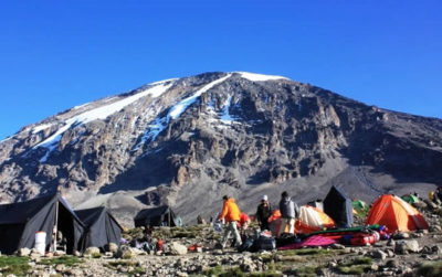
After the briefing on the lemosho route,the hikers together with the clues,drives for an hour from moshi to Londorossi Park Gate (2100m) which is a 45 minutes drive.the hike is a three hours through the rain forest,whereby an afternoon lunch break is served ,before arriving at mti mkumbwa camp 2750m.dinner and overnight at the camp.
Day 3 Mti Mkubwa Camp (2750m) – Shira 2 Camp (3840m)
- Hiking time: 6.5 hours
- Habitat: Moorland
The hikes today will be on an ascent rain forest with the heather moorland zone.hikers will pass through the streams,and over a plateau that leads to Shira 2 Camp (3840m).the shira 2 camp will have spectacular view of the Western Breach and its glaciers in the East,tent camping will be set once you arrive at the camp,this night is cold and therefore hikers are adviced to have the good trekking/hiking gears to prevent freezing at night
Day 4 Shira (3840m) – Lava Tower (4630m) – Barranco Camp (3950m)
- Hiking time: 7 hours
Distance: Approximately 15 kilometers
Habitat: Semi desert
after an early morning breakfast leave the moorland environment and enter the semi desert and rocky landscape,where the hike will be 5 hours in the east,where the lava tower 4630m is seen.Packed lunches are served at the Tower and hikers have the option of climbing the massive Lava Tower weather permitting. At this point of the hike, it is normal for hikers to start feeling the effects from the altitude including headaches and shortness of breath.
After lunch, you will descend from Lava Tower (4630m) to the Barranco Campsite (3950m). The 6800m descent gives hikers a huge advantage to allow their bodies to adjust to the conditions of high altitude. The descent to camp takes around 2 hours to reach. It is located in a valley below the Breach and Great Barranco Wall (“Breakfast Wall”). Drinking and washing water and dinner will be served as hikers view the sun setting.
Day 5 Barranco Camp (3950m) – Karanga Camp (3950m)
Hiking time: 4-5 hours
Distance: Approximately 5 kilometers
Habitat: Alpine desert
This is a short hiking day meant for acclimatization. After an early morning breakfast, it is now time to conquer the Great Barranco Wall! Although it may look intimating at first glance, hikers state that this Class 2 hike is usually much easier than they anticipated. At the top of the Wall, you will have a view of Heim Glacier and will be above the clouds. The trail then winds up and down in the Karanga Valley. You will spend the night at Karanga Camp (3950m) and enjoy dinner and washing at the site.
Day 6 Karanga Camp (3959m) – Barafu Hut (4600)
- Hiking time: 2-3 hours
- Distance: Approximately 4 kilometers
- Habitat: Alpine desert
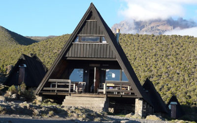
- After breakfast, you will begin your ascent. The trail intersects with the Mweka Route, which is the trail used to descend on the final two days. As you continue hiking for an hour, you will reach Barafu Hut. This is the last water stop for the porters because there is no accessible water at Barafu Camp (4550m). The word “barafu” in Swahili means “ice” and this camp is located on a rocky, exposed ridge. Tents will be exposed to wind and rocks so it is important for hikers to familiarize themselves with the campsite before dark. An early dinner will be served so hikers can rest before attempting the summit the same night. Your guide will brief you in detail on how to prepare for summit night. Get to sleep by 19:00!
-
Day 7 summit attempt barafu camp 4600m-uhuru peak 5895m-mweka 3100m
- Hiking time: 8 hours to reach Uhuru Peak, 7-8 hours to descend to Mweka
Distance: Approximately 7 kilometers ascent and 23 kilometers descent
Habitat: Stone scree and ice-capped summitYour guide will wake you around 23:30 for tea and biscuits. You will then begin your summit attempt. The route heads northwest and you will ascend over stone scree. During the ascent, many hikers feel that this is the most mentally and physically challenging part of the climb. In about 6 hours, you will reach Stella Point (5685m), located on the crater rim. After enjoying the magnificent sunrise, you will continue ascending for about 2 hours on a snow-covered trail to Uhuru Peak (5895m). Reaching the summit of Mt. Kilimanjaro is a lifetime accomplishment! You will be able to spend a short time on the summit taking photographs and drinking tea before the descent to Barafu begins. The hike down to Barafu Camp takes about 3 hours.At camp, you will rest and enjoy a hot lunch in the sun. After eating, you will continue descending down to Mweka Hut (3100m). The Mweka Trail will lead you through the scree and rocks to the moorland and eventually into the rain forest. Mweka Camp (3100m) is located in the upper rain forest, so fog and rain should be expected. You will have a dinner, wash, and rest soundly at camp.
Day 8 Mweka Camp (3100m) – Mweka Gate (1980m)
Hiking time: 3 hours
Distance: Approximately 15 kilometers
Habitat: ForestFollowing a well-deserved breakfast, your staff will have a big celebration full of dancing and singing. It is here on the mountain that you will present your tips to the guide, assistant guides, chef(s), and porters. After celebrating, you will descend for three hours back to Mweka Gate. The National Park requires all hikers to sign their names to receive certificates of completion. Hikers who reached Stella Point (5685m) receive green certificates and hikers who reached Uhuru Peak (5895m) receive gold certificates. After receiving certificates, hikers will descend into the Mweka village for 1 hour (3 kilometers). You will be served a hot lunch then you will drive back to Arusha for long overdue showers and more celebrations.
Lemosho Route 7 days Rates:
- Price enquire:
-
The following will be included in the prices.accommodation in camps while trekkingfood- vegetarian & non vegetarian,2 transfer from Moshi -park gate- return,all government park fees,English speaking mountain guides and porters.
Not included
- Personal clothing and equipment
- accomodation in moshi /Arusha
- Tips and gratuities for guides and porters
- Beverages while not on the mountain
- Enquiries and Bookings
- Please fill in the form below to book or make further enquiries